Plane spotting is generally a very easy hobby to practice, you can often get started with things you already own plus a few additional free tools to make the experience a bit easier.
In this post I’ll highlight some of the tools and techniques that you might want to use if you are first getting in to the plane spotting hobby.
Basics
Before you get started there is a bit of basic information that is worth knowing primarily about how aircraft operate in and around an airport.
Landing & Takeoff Direction
For the purposes of spotting, the most important of these things is where aircraft will be landing and taking off. Aircraft almost always operate in to the wind. That said, if the wind is blowing from the west, you will often find aircraft landing and taking off in a westerly direction.
It is for this reason that airports, especially larger ones, will have more than one runway. In the event that winds shift, ATC (air traffic control) will change active runways such that arriving and departing aircraft are positioned most closely to the direction the wind is blowing from.
Runway names
So naturally the next bit of information that you should know is how do you identify the runways at all? A runway will have a name that consists of a two digit number occasionally followed by either a L, R or C.
The two digit number corresponds to the direction, in degrees, that the runway faces. For example, if you had a runway that went from directly east to directly west, the runway would have the number 27 (because it would be situated at 270°, or due west). In the event that the number has a zero at the end, that zero is dropped; however in the event the number is a single digit, a zero will be prepended. Here are some other examples:
| Description | Runway Number | Explanation |
| Runway that faces directly north | 36 | 360° is due north on a compass, we drop the trailing zero |
| Runway that faces directly north northwest | 31 | 310° is due directly north northwest on a compass, we drop the trailing zero |
| Runway that faces directly north northeast | 04 | 40° is due directly north northeast, we drop the trailing zero but since we end up with a single digit, we add a proceeding zero |
This system of dropping the zero at the end and prepending one if the result is a single digit results in all runways having a number that is two digits with no overlap between the 360° possible.
The remaining component, a letter at the end, isn’t always present, but in the event that it is, it is used to differentiate multiple runways at the same airport facing in the same direction.
For example, if you had an airport with two runways facing directly west, you would have two runways with the name 27. To differentiate between the two, airports will call them 27L (27 left) and 27R (27 right). The left/right directionality is from the perspective of looking directly down the runway.
At even larger airports the number of like-named runways can go up to three in total: 27L (left), 27C (center) and 27R (right).
At the largest airports, this might not be sufficient and you might find six or more parallel runways. In the case that the airport has more than three runways facing the same direction, the names will often be incremented or decremented by a digit. For example, if our hypothetical airport had 6 runways all facing west, we could have:
- 27L
- 27C
- 27R
- 28L
- 28C
- 28R
In fact, this layout is quite similar to the way that one of the world’s largest airports, Chicago O’Hare, is designed with 27L and 27R in the north and 28L, 28C and 28R in the south.
There is one last thing to know about runway names – every runway actually has two separate names. While our hypothetical due west runway can be used when the wind is blowing from the west, we could also use that same runway when winds are blowing from the east. How would we make the distinction between the different directions when pilots are provided instructions though? We use two different names!
If a pilot is instructed to make a westerly landing on our western runway, 28, the air traffic controller will call it runway 28. However, say the winds shifted and now are blowing directly due east, now the air traffic controller would call this runway 09 (due east is 90°, drop the zero at the end, prepend one, hence 09).
This said, our mega airport with 6 runways would facing west/east would have a total of 12 possible runways:
- 27L
- 27C
- 27R
- 28L
- 28C
- 28R
- 09L
- 09C
- 09R
- 10L
- 10C
- 10R
The whole point of all this effort is to ensure that an airport is able to serve traffic with predominantly head-on winds for most of the time the airport is operational. That is to say, an airport like the one we have been describing with east/west runways is most likely to see predominantly winds blowing from the east or west for most of the year. Examining how runways are configured at an airport is a good way to get a quick idea for predominant wind direction.
Typical Airport Operations
With the knowledge around runway usage, it is much easier to make predictions for where aircraft will most likely be given the day and time of day you will be spotting – just check the winds. If the winds are coming from the west and your local airport has a runway due west, it is a pretty safe bet that setting up at a spot at the end of that runway will get you the best view.
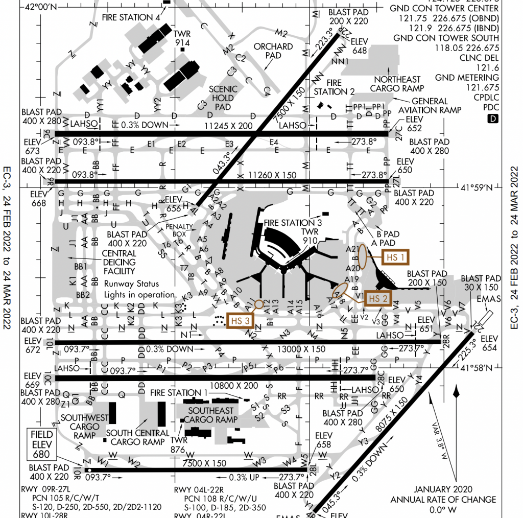
Beyond this, for larger airports there is generally a bit of a learning curve to accurate predict where specific aircraft might be going. For example, at Minneapolis/St. Paul International (MSP), all of the heavy traffic (big planes) almost always use the south runway (12R/30L). This is because 1) this is the longest runway and 2) these larger aircraft tend to park at locations closer to this runway.
This is information I have because I have experience at MSP, but you may lack this sort of information when you first start spotting. That said, be sure to pay attention to what you see on each runway. Airports are run by people, so there is almost always a pattern to where certain aircraft land and takeoff. Be observant (or ask a fellow spotter) and you will be able to better position yourself.
Tools
With that basic knowledge out of the way, lets discuss a few tools that will help you employ this new knowledge to be a more successful spotter.
SpotterGuide.net
You should be able to form a reasonable idea of where aircraft will be landing and taking off given your knowledge of the airport you will be spotting at, as well as the known wind direction. That is great and all, but where, specifically, should you position yourself for the best views? For that, SpotterGuide.net will be your best friend.
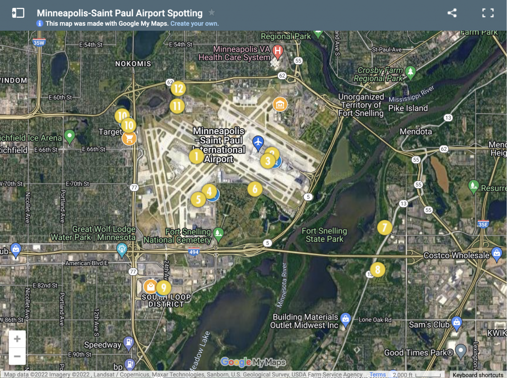
SpotterGuide.net is a website containing lists of known spotting locations at most of the major airports in North America and around the world. When you pull up the page for a specific airport, you will be greeted with ratings (such as how many different airlines visit this airport, how easy it is to see the aircraft, how easy it is to see ground movements) and information about typical runway usage (like that bit of knowledge I shared above about heavies using 12R/30L at KMSP).
Below that you’ll find a map like the one below, showing all of the known spotting locations in the area.
So, with your knowledge of the weather and subsequently what runway is likely to be in use, you can select the best spot for you on any given day.
In addition, each spot will list requirements (such as a ladder being useful), facilities and occasionally warnings about law enforcement or security, if they are relevant. Take care to familiarize yourself with all the information present on SpotterGuide.net to ensure you have the best experience possible while out in the field.
Windy
The general weather sources are often okay for getting weather forecasts, but there are much better tools out there for extended forecasts, the most commonly used is Windy. Windy will provide a map with lines indicating the current wind direction, faster animations and redder colors mean higher winds and vice versa. Additionally, you can use a time selector at the bottom to see what the expected wind direction will be at, say, tomorrow at 3 PM.
FlightRadar24
Barbers have their shears, mechanics have their wrenches and plane spotters have FlightRadar24 (FR24, in shorthand). FR24 is arguably one of the most important tools in the spotter’s tool belt. FR24 provides a live look at active fights anywhere in the world.
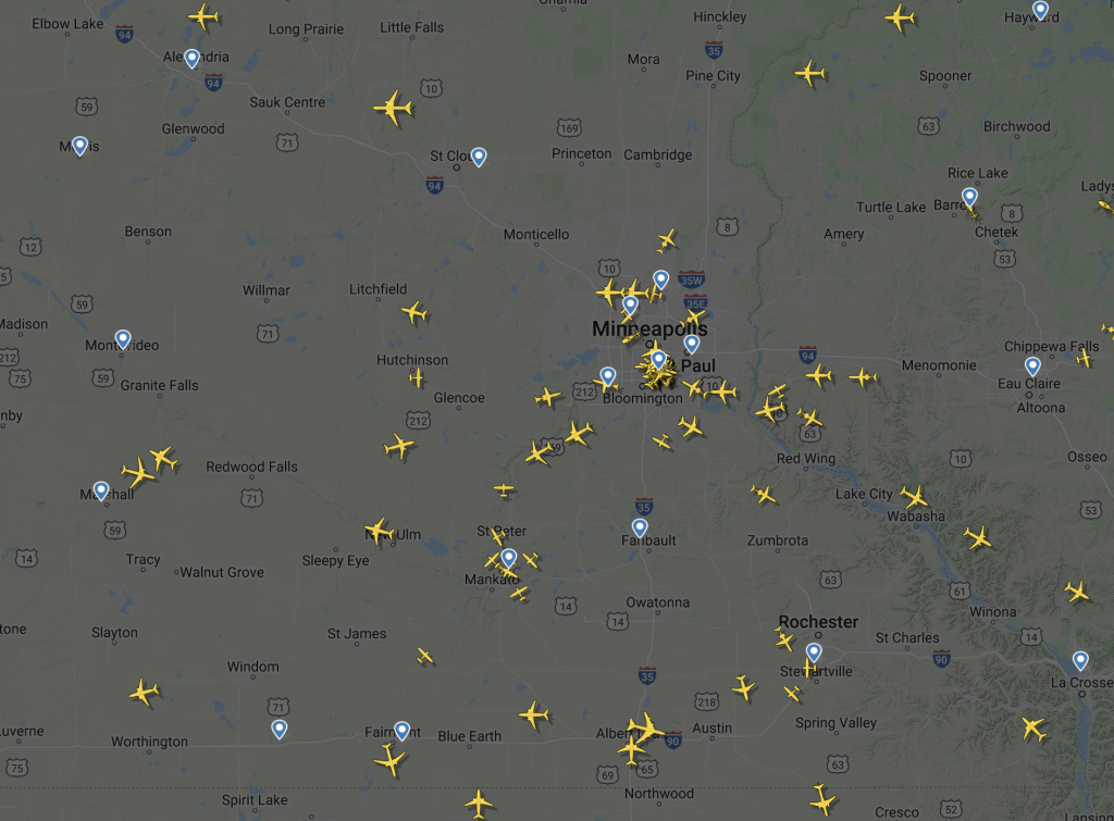
If you select the area around the airport you intend to spot at, you can see aircraft as they approach the airport, or aircraft on the ground as they turn on their transponders (indicating they are about ready to move). In addition to live views, FR24 provides a schedule for known arrival and departures, based on flight plans filed by the airlines.
A common practice would be to use FR24 the day before you intend to spot to get an idea of whether or not any rare aircraft might be visiting your airport and, if so, what time they are due in/out.
FR24 is also very useful if you are ever curious about where an aircraft you have seen is leaving from and going to, or if you are looking to track the progress of a particular flight. The information provided in FR24 is maintained using a large network of ADS-B receivers that ingest data broadcast by the aircraft themselves – that said, this is likely the most accurate information you could obtain about the speed, altitude and status of an aircraft in flight.
JetTip
FlightRadar24 is excellent, but it can get very old manually scrolling through the timetables looking for aircraft that interest you – enter JetTip!
JetTip is a paid service that essentially crawls the timetables for you, automatically notifying you of aircraft landing at or taking off at airports you add to a list. It works by comparing how often a certain aircraft visits the airport to help weed out false alarms. For example, an Antonov AN-124 visiting a small town airport would send an alert letting you know the arrival and departure time, however if you happen to live near the Antonov airport in Ukraine, this would not trigger an alert because this is a common aircraft there.
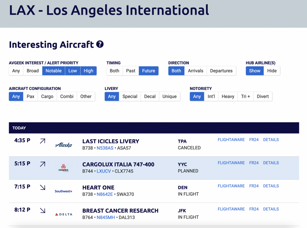
JetTip maintains an extensive database of interesting aircraft, including those with special liveries, and will promptly notify you of such an aircraft should a flight plan be filed into or out of the airports you select.
JetTip will run you $5 USD, but it is well worth it if you are serious about getting those rare and interesting aircraft.
LiveATC.net
If you are very serious about positioning yourself properly for a specific plane (or if you just like hearing the radio chatter), LiveATC.net is a must have. LiveATC.net is a free tool that allows you to listen in on a large number of radio frequencies across the world. This would enable you to hear air traffic controllers provide instructions to aircraft in the air and on the ground.
If you are looking for a specific aircraft, you can tune in to the approach frequency at your local airport and listen in for landing clearance so you know which runway to be positioned near to get the best view possible.
Conclusion
With the knowledge and tools above you should be well equipped to take your first trip out to the airport and spot some aircraft.
If you have any questions, please feel free to throw them in the comments – I’d love to chat more!